Mexico’s President Pushes Back After Trump Posts Map Showing Mexico Under U.S. Flag
Verdict: Substantially accurate, but the graphic leaves out important context.
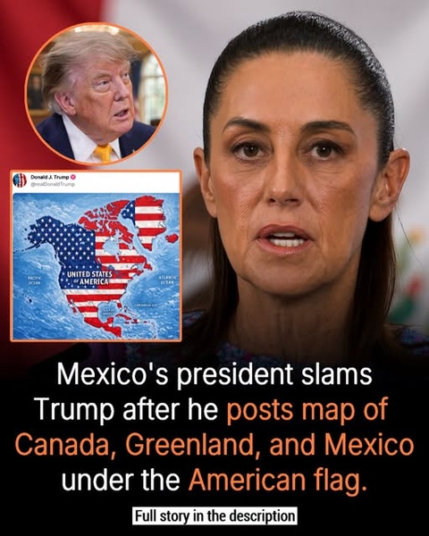
The graphic is based on a real event. On September 7, 2026, President Donald Trump posted a map on Truth Social depicting Mexico, Canada, Greenland, Iceland, Central America and parts of the Caribbean under the colors of the U.S. flag, with the broader area labeled “United States of America.” Trump posted the image without a caption or explanation.
The image supplied with the post is consistent with that reported map.
Sheinbaum did respond
Mexican President Claudia Sheinbaum responded publicly, declaring that Mexico “is not and will not be a colony or protectorate of any foreign country.” She made the statement on September 7 in response to the appearance of Mexico on Trump's map.
Sheinbaum reinforced the message the following day, saying Mexico would defend its sovereignty and independence against any foreign power.
So the graphic's description that Mexico's president pushed back against Trump after the map was posted is accurate.
But did Trump actually announce that he was annexing Mexico?
No. That's where the graphic needs context.
Trump's post itself contained no written announcement, policy statement or explanation saying that the United States was formally annexing Mexico. Multiple reports noted that the image was posted without explanation.
The map is nevertheless provocative because it depicts sovereign countries as though they were part of the United States. It also comes against a broader backdrop of Trump's expansionist rhetoric.
Trump has repeatedly discussed making Canada the 51st U.S. state and has continued pursuing or discussing U.S. acquisition of Greenland, which is an autonomous territory within the Kingdom of Denmark.
The administration has also taken symbolic steps involving neighboring geography. On August 27, Trump issued an executive order directing the federal government to use “Lake America” for Lake Ontario in federal references.
The map was actually broader than the graphic suggests
Interestingly, the graphic focuses on Canada, Greenland and Mexico, but Trump's map went considerably further.
Reports say it also portrayed Iceland, Central America and portions of the Caribbean under the American flag. Iceland reacted particularly strongly: its government summoned the U.S. ambassador and called the post inappropriate.
That makes the controversy larger than simply a dispute between Washington and Mexico City.
Why this matters diplomatically
The United States and Mexico remain deeply interconnected economically and politically, particularly through trade and migration. A presidential social-media image portraying Mexico as U.S. territory can therefore carry considerably more diplomatic weight than an ordinary internet meme.
At the same time, it is important not to turn an ambiguous social-media image into a formal policy announcement that Trump did not make.
The strongest factual formulation is:
Trump posted a map depicting Mexico and several other foreign territories under the U.S. flag; Mexico's president responded by reaffirming that Mexico is neither a colony nor a protectorate of another country.
That is supported by the available reporting.
Bottom line
The graphic is essentially accurate about the incident and Sheinbaum's reaction. The missing context is that Trump did not accompany the map with a statement announcing an annexation of Mexico. It was an unexplained social-media post, albeit one that fits into Trump's broader rhetoric about territorial expansion involving Canada and Greenland.
Comments (0)
Loading comments...
May You Like
Obama Steps Back Into the Political Spotlight as Democrats Target Trump’s Senate Majority
OBAMA STUNS ON INSTAGRAM: MESSAGE MARKING 34-YEAR MILESTONE SPARKS A BUZZ