Trump Posts Expansion Map Showing Canada, Mexico, Greenland and Caribbean Under U.S. Flag
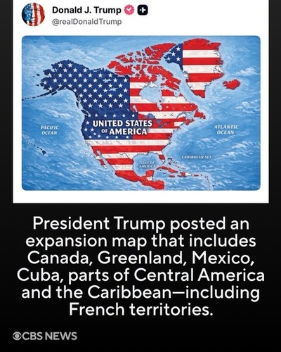
WASHINGTON — President Donald Trump has reignited controversy over his vision for a dramatically expanded United States after sharing a map on social media that depicts Canada, Mexico, Greenland, Iceland and large parts of Central America and the Caribbean under the American flag.
The image, posted on Trump’s Truth Social account without an accompanying explanation, portrays a vastly enlarged United States stretching across much of North America and into the Caribbean. The map labels the expanded territory “United States of America.”
The image is similar to the graphic provided above, which shows the United States flag covering Canada, Greenland, Mexico, Cuba and other territories, including French Caribbean territories.
Trump Gives No Explanation for the Map
Trump did not provide a detailed caption explaining whether the image was intended as a political statement, a joke, a vision for American foreign policy or simply a provocative social-media post.
The lack of explanation has nevertheless attracted international attention because Trump has repeatedly spoken about expanding American influence beyond the country's existing borders.
The Associated Press reported that the latest map revived Trump's previous comments about making Canada the 51st U.S. state and his repeated interest in acquiring Greenland, the self-governing territory of Denmark.
The map also comes after a series of unusual posts by Trump during the Labor Day weekend, including images and statements involving territorial names and American expansion.
Canada, Greenland and Iceland Draw Particular Attention
The inclusion of Canada and Greenland is especially significant.
Trump has repeatedly argued that Greenland is strategically important to the United States because of its location and natural resources. His comments about acquiring the territory have already caused tensions with Denmark and Greenlandic officials.
The latest map also included Iceland, prompting a direct diplomatic response.
Iceland summoned the U.S. ambassador after the country appeared under the American flag in Trump's map. Icelandic officials described the post as inappropriate, while Iceland's prime minister called it “ridiculous,” according to the Washington Post and Reuters.
Danish officials have likewise criticized Trump's territorial imagery, with Denmark's foreign minister describing the map as disturbing and inappropriate.
Mexico Responds: “Free, Independent and Sovereign”
The map also drew attention in Mexico, where President Claudia Sheinbaum pushed back against the imagery.
Sheinbaum said Mexico is a free, independent and sovereign country and would not become a colony or protectorate of another nation. Her response reflected broader concerns in Mexico over Trump's increasingly confrontational rhetoric toward America's southern neighbor.
The timing is particularly notable because Washington and Mexico City are currently negotiating a bilateral trade agreement ahead of the November 2026 U.S. midterm elections.
Reuters reported on September 11 that the two governments are accelerating negotiations, with tariffs, automobile production and Chinese investment among the issues on the table.
The Map Does Not Change U.S. Borders
Despite the striking appearance of the graphic, the social-media post does not itself change the borders of the United States.
Changing the status of foreign territory would involve international agreements and U.S. constitutional and congressional processes. The Constitution gives Congress broad authority over U.S. territories and provides that new states are admitted into the Union by Congress.
There is also no indication in the reporting reviewed that the White House has announced a formal plan to incorporate Canada, Mexico, Iceland or the Caribbean territories into the United States as a result of the map.
That distinction is important: the map is political imagery, not evidence that those countries have actually become part of the United States.
A Broader Pattern of Territorial Rhetoric
The latest post fits into a broader pattern of Trump using maps, renamed geographic features and social-media imagery to promote an expansive conception of American power.
In recent days, Trump has also floated changing the name of New Mexico to “New America” and has used the name “Lake America” for Lake Ontario in posts, according to media reports.
At the same time, tensions with Canada have continued to develop over trade. The White House announced new restrictions on certain Canadian products in September, demonstrating that Trump's relationship with Canada involves concrete economic policy as well as symbolic territorial rhetoric.
Why the Map Matters
The significance of Trump's map may therefore be less about an immediate change in U.S. territory and more about the message it sends to neighboring countries and American allies.
Canada, Mexico, Greenland, Iceland and Caribbean nations are independent countries or territories with their own governments and international relationships. Putting them under the U.S. flag in an image posted by the American president can carry diplomatic consequences even when no formal policy accompanies the post.
For critics, the image reinforces concerns that Trump's “America First” agenda is evolving toward a more openly expansionist foreign policy.
For Trump's supporters, such imagery can be viewed as an expression of American strength and influence.
But as of now, there is no evidence that the countries and territories shown on the map have been incorporated into the United States.
Bottom Line
Trump's latest map has generated a new wave of international controversy by portraying a U.S. that stretches across Canada, Mexico, Greenland, Iceland, Central America and the Caribbean.
The post was made without an explanation, and it does not itself alter international borders. But coming amid Trump's repeated comments about Greenland, Canada and America's influence in the Western Hemisphere, the image has once again raised questions about how far the president intends to push his vision of an expanded American sphere of influence.
Comments (0)
Loading comments...
May You Like
South Korea–Ukraine Rift Deepens Over North Korean POW Transfer as PURL Draws New Scrutiny
South Korea–Ukraine Rift Deepens Over North Korean POW Transfer as PURL Draws New Scrutiny