Trump Posts Map Depicting Canada, Mexico, Greenland and French Territories Under U.S. Flag
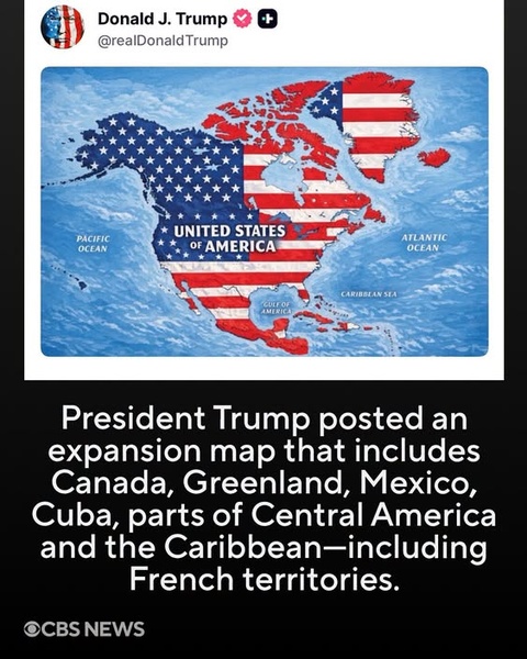
Verdict: Accurate as a description of the image, but the map is not a formal annexation announcement.
The graphic accurately captures the central fact: President Donald Trump posted a map on September 7, 2026, on Truth Social showing a dramatically expanded United States, with the American flag covering Canada, Mexico, Greenland, Iceland, Central America and numerous Caribbean territories. The image itself was posted without a caption or explanation.
The graphic's claim that the map includes French territories is also correct.
What exactly does Trump's map show?
The map goes considerably beyond the United States' existing borders.
Reports examining the image say it depicts:
- Canada
- Mexico
- Greenland
- Iceland
- Central America
- Cuba
- Haiti
- Jamaica
- the Dominican Republic
- several other Caribbean islands
- French overseas territories including Guadeloupe, Martinique, Saint-Martin and Saint-Barthélemy
- Saint-Pierre-et-Miquelon, the French territory off Canada's Atlantic coast
All are visually incorporated into a giant area labeled “United States of America.”
The map also labels the Gulf of Mexico as “Gulf of America,” consistent with Trump's administration having adopted that terminology for U.S. federal usage.
The French-territory detail is particularly significant
The graphic isn't merely showing countries that Trump has previously discussed acquiring.
The map also absorbs territories that are unambiguously French territory, including Guadeloupe and Martinique.
French reporting identified Guadeloupe, Martinique, Saint-Martin, Saint-Barthélemy and Saint-Pierre-et-Miquelon as being represented beneath the U.S. flag.
That means the image isn't simply a visualization of Trump's well-known interest in Greenland or his statements about Canada. It depicts a much broader expansion encompassing territories belonging to France, Denmark and numerous independent states.
But Trump did not announce an annexation
This distinction is crucial.
Trump's post consisted of the map without an accompanying statement explaining what it meant. Reuters, AP and other outlets all reported that the image was posted without explanation.
Therefore, it would be inaccurate to write:
“Trump announced that the United States has annexed Canada, Mexico and the Caribbean.”
He did not make such a formal announcement in the post.
A more accurate description is:
Trump posted a map portraying a vastly expanded United States that visually incorporates numerous foreign countries and territories.
That distinction matters because a social-media image does not itself change international borders or sovereignty.
Nevertheless, the map comes amid real expansionist rhetoric
The post didn't appear in isolation.
Trump has repeatedly spoken about Canada becoming the 51st U.S. state and has pursued the idea of obtaining Greenland, an autonomous territory within the Kingdom of Denmark. Those positions have already produced substantial diplomatic friction.
The map therefore has a very different political meaning from an ordinary satirical image. It comes from a president who has publicly discussed territorial expansion.
Trump has also used geographic renaming as a political instrument, including his administration's use of “Gulf of America” and more recent proposals concerning other geographic names.
Other governments have reacted
The strongest immediate diplomatic reaction came from Iceland.
Iceland's foreign minister summoned U.S. Ambassador Billy Long and described the map as “completely inappropriate.” Icelandic officials objected specifically to the depiction of Iceland as part of the United States.
Mexican President Claudia Sheinbaum also responded by emphasizing that Mexico would not become a colony or protectorate of a foreign country.
Cuban officials likewise rejected the implication that Cuba could again become a U.S. possession.
The reactions demonstrate why the map has been treated as more than an innocuous internet image: foreign governments interpreted it as a provocative statement about their sovereignty, even though Trump did not explain its intended meaning.
Is the map legally meaningful?
No—not by itself.
The United States cannot simply change another country's borders by publishing a map on social media. Annexation of another sovereign state's territory would involve extraordinarily consequential questions of international law, treaties, military force and U.S. constitutional authority.
The map therefore represents political messaging, not a legally effective change to the borders of the United States.
Bottom line
The CBS News graphic is substantially accurate.
Trump really did post the map, and it really does visually incorporate Canada, Mexico, Greenland, Iceland, Central America, Cuba, parts of the Caribbean and French overseas territories into a U.S.-flag-covered area labeled “United States of America.”
The important caveat is that Trump provided no explanation and did not formally announce the annexation of these territories. The map should therefore be described as a provocative depiction of territorial expansion—not proof that the United States has actually claimed or acquired those territories.
Comments (0)
Loading comments...
May You Like
FIGHT OVER OBAMA’S IRAN POLICY
TRUMP’S OHIO WARNING UNDER THE SPOTLIGHT