Trump Shares AI-Generated Map Showing American Flag Covering Canada, Mexico, Greenland, and Cuba — Without a Word of Explanation
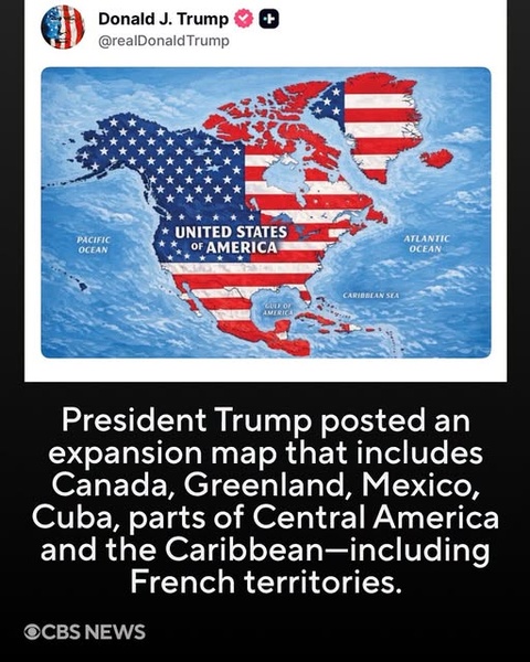
President Donald Trump set off a diplomatic firestorm Monday after posting an AI-generated map on Truth Social that depicts the United States flag stretching across most of North America and the Caribbean — from Canada and Mexico to Greenland, Iceland, Cuba, and even French territories — with the entire landmass labeled simply “United States of America.”
WASHINGTON — President Donald Trump posted an AI-generated map on his Truth Social platform Monday morning that showed the American flag superimposed over the United States, Canada, Mexico, part of Central America, Greenland, Iceland, and Caribbean islands including Cuba and Jamaica. The image bore no caption, no explanation, and no indication of whether it represented a policy proposal — but the message was unmistakable.
The map, which labeled the entire expanded territory “United States of America,” also covered French territories such as St. Barts, Guadeloupe, Martinique, and Saint-Pierre-et-Miquelon, according to CBS News .
The post came just one day after Trump shared an AI-altered map of New Mexico with the word “Mexico” crossed out and replaced by “America,” suggesting the state be renamed “New America” .
Iceland Summons U.S. Ambassador
The reaction from affected nations was swift and sharp.
Iceland summoned U.S. Ambassador Billy Long to explain the post, with the Foreign Ministry describing it as “completely inappropriate,” according to Iceland’s public broadcaster RÚV .
Mexican President Claudia Sheinbaum issued a pointed response on X: “In the month of the homeland, we reaffirm that Mexico is neither nor will be a colony or protectorate of any foreign country. Proudly we are a free, independent, and sovereign nation” .
Canadian Prime Minister Mark Carney had previously addressed Trump’s annexation talk during an Oval Office meeting in May, telling the president: “As you know from real estate, there are some places that are not for sale.” Trump responded: “Never say never” .
Expert: ‘Classic Provocation’ — But Don’t Dismiss It
Craig Agranoff, a political science professor at Florida Atlantic University, told Newsweek that the map appeared intended as political messaging rather than a formal declaration of policy .
“President Trump often uses maps and renamed landmarks as political theater, and posting an image with no text is classic provocation rather than a formal claim. That said, countries should not treat it as empty noise,” Agranoff said. “The practical risk is not an overnight annexation. It is that the image becomes part of a pattern that complicates diplomacy, trade talks and security cooperation” .
A Wider Pattern of Territorial Rhetoric
The map is the latest in a series of provocative geographic gestures from the president. He has repeatedly expressed interest in bringing Greenland under U.S. control, suggested Canada could become the “51st state,” and claimed the Panama Canal should be returned to American control .
In January 2025, Trump signed an executive order directing the Gulf of Mexico to be renamed the “Gulf of America” in federal documents — a change unrecognized internationally . Last month, he ordered Lake Ontario to be renamed “Lake America” amid escalating trade tensions with Canada .
On Sunday, Trump also shared an image bearing the words “THE MOON IS OURS” alongside a U.S. flag .
What the Viral Graphic Captures
The viral graphic featuring Trump’s post and the caption “President Trump posted an expansion map that includes Canada, Greenland, Mexico, Cuba, parts of Central America and the Caribbean—including French territories” is accurate to the letter.
Every element of the caption is verified: the map covered Canada, Greenland, Mexico, Cuba, and parts of Central America and the Caribbean. It also included French territories — Guadeloupe, Martinique, Saint-Barthélemy, Saint-Martin, and Saint-Pierre-et-Miquelon .
What remains unclear is the president’s intent. The White House has not indicated that the image represents a formal policy proposal . But for governments from Ottawa to Mexico City to Copenhagen, the message was received loud and clear — and it did not go unanswered.
The Bottom Line
| What the graphic suggests | What actually happened |
|---|---|
| Trump posted an expansion map | He shared an AI-generated map with no caption |
| It covered Canada, Mexico, Greenland, Cuba | The map also included Iceland and French territories |
| It sparked international reaction | Iceland summoned the U.S. ambassador |
| It follows a pattern | Trump has pushed territorial claims and renamings for months |
The map may have been posted without a single word of explanation. But in the world of Trump-era geopolitics, the silence spoke volumes — and the world was listening.
For allies and adversaries alike, the message was clear: the president’s territorial ambitions are not confined to the United States. And as with so much of Trump’s rhetoric, the rest of the world must now decide whether to treat it as theater — or warning.
Comments (0)
Loading comments...
May You Like
TRUMP’S OHIO WARNING UNDER THE SPOTLIGHT